Tag Archives: topic modelling

A thesis relived: using text analytics to map a PhD journey


Your thesis has been deposited.

Is this how four years of toil was supposed to end? Not with a bang, but with a weird sentence from my university’s electronic submission system? In any case, this confirmation message gave me a chuckle and taught me one new thing that could be done to a thesis. A PhD is full of surprises, right till the end.

But to speak of the end could be premature, because more than two months after submission, one thing that my thesis hasn’t been yet is examined. Or if it has been, the examination reports are yet to be deposited back into the collective consciousness of my grad school.

The lack of any news about my thesis is hardly keeping me up at night, but it does make what I am about to do in this post a little awkward. Following Socrates, some people would argue that an unexamined thesis is not worth reliving. At the very least, Socrates might have cautioned against saying too much about a PhD experience that might not yet be over. Well, too bad: I’m throwing that caution to the wind, because what follows is a detailed retrospective of my PhD candidature.

Before anyone starts salivating at the prospect of reading sordid details about about existential crises, cruel supervisors or laboratory disasters, let me be clear that what follows is not a psychodrama or a cautionary tale. Rather, I plan to retrace the scholastic journey that I took through my PhD candidature, primarily by examining what I read, and when.

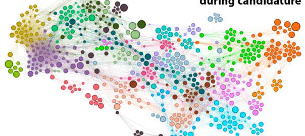
I know, I know: that sounds really boring. But bear with me, because this post is anything but a literature review. This is a data-driven, animated-GIF-laden, deep-dive into the PhD Experience. Continue reading A thesis relived: using text analytics to map a PhD journey
Tracking and comparing regional coverage of coal seam gas

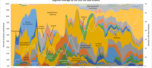
In the last post, I started looking at how the level of coverage of specific regions changed over time — an intersection of the Where and When dimensions of the public discourse on coal seam gas. In this post I’ll continue along this line of analysis while also incorporating something from the Who dimension. Specifically, I’ll compare how news and community groups cover specific regions over time.

Regional coverage by news organisations

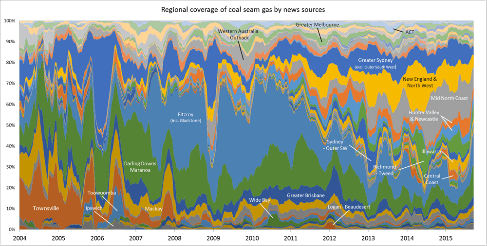
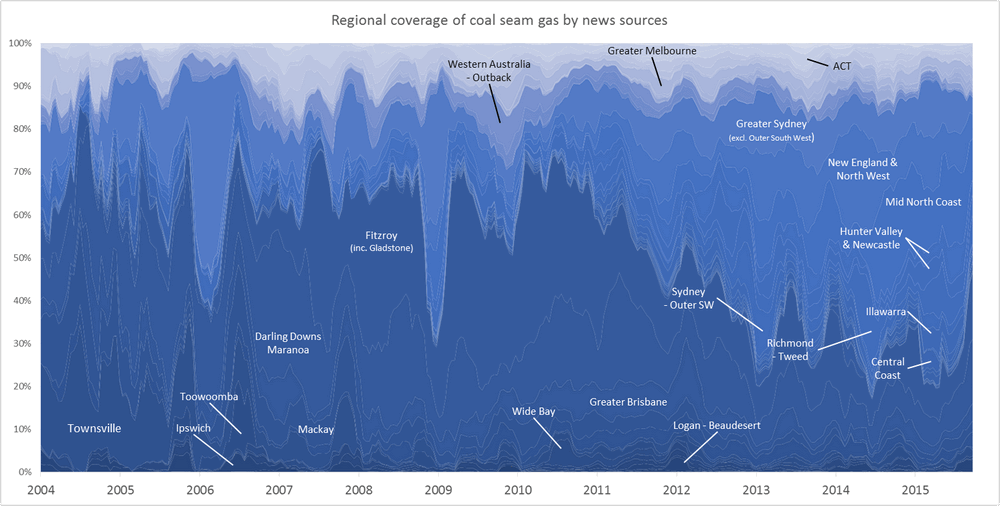
One of the graphs in my last post compared the ratio of coverage of locations in Queensland to that of locations in New South Wales. Figure 1 below takes this a step further, breaking down the data by region as well. What this graph shows is the level of attention given to each region by the news sources in my database (filtered to ensure complete coverage for the period — see the last post) over time. In this case, I have calculated the “level of attention” for a given region by counting the number of times a location within that region appears in the news coverage, and then aggregating these counts within a moving 90-day window. Stacking the tallies to fill a fixed height, as I have done in Figure 1, reveals the relative importance of each region, regardless of how much news is generated overall (to see how the overall volume of coverage changes over time, see the previous post). The geographic boundaries that I am using are (with a few minor changes) the SA4 level boundaries defined by the Australian Bureau of Statistics. You can see these boundaries by poking around on this page of the ABS website.

The regions in Figure 1 are shaded so that you can see the division at the state level. The darker band of blue across the lower half of the graph corresponds with regions in Queensland. The large lighter band above that corresponds with regions in New South Wales. Above that, you can see smaller bands representing Victoria and Western Australia. (The remaining states are there too, but they have received so little coverage that I haven’t bothered to label them.) I have added labels for as many regions as I can without cluttering up the chart.

Figure 1. Coverage of geographic regions in news stories about coal seam gas, measured by the number of times locations from each region are mentioned in news stories within a moving 90-day window. The blue shadings group the regions by state. Hovering over the image shows a colour scheme suited to identifying individual regions. You can see larger versions of these images by clicking here and here.

Continue reading Tracking and comparing regional coverage of coal seam gas

The Who dimension

My last post focussed on my progress in making sense of the Where dimension of the public discourse on coal seam gas, including how the Where intersects with the What. This post is about the Who. Somehow, I’ve managed to say almost nothing on this blog so far about the Who dimension of my data. Nearly all of what I’ve written has been about the What, Where and When. It’s time to rebalance this equation.

Until recently, the Who dimension of my data was represented only by a pool of Australian news organisations (at more than 300 sources, it was admittedly a rather large pool), as I was working just with the data I retrieved from the Factiva news database. Now that I have incorporated additional data that I scraped from the websites of community, governments and industry stakeholders (as discussed in my last post), the Who dimension has become a little bit richer. Before I start exploring questions about specific stakeholders and news organisations, or make decisions about which sources I might want to exclude all together, I want to survey the full breadth of sources in my data. I want the birds-eye view. But how to get it?

Who × When ÷ Where = Wha…?

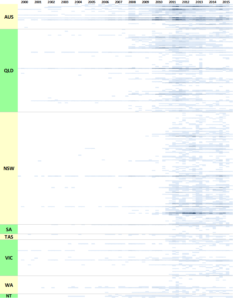
In the previous post, I listed all of my stakeholder sources in colourful tables showing the production of content over time. Initially I thought that doing the same thing with 300 news sources would be ridiculous, but then I figured it might just be ridiculous enough to work. Through a creative deployment of Excel’s conditional formatting feature, I managed to make what you see in Figure 1. Each horizontal band is an individual news source, and the darkness of the band corresponds with the number of articles produced by that source per quarter. Within each state, the sources are grouped by region, although I haven’t indicated where these groupings begin and end (maybe next time!).

Figure 1. The temporal coverage of all news sources in my corpus.
Figure 1. The temporal coverage of all news sources in my corpus. Each horizontal band represents a news source, while the shading indicates the number of articles published per quarter.

For an experiment that I didn’t take very seriously, this viz actually isn’t too bad. It highlights several features of the data that are useful to know. Firstly, it shows that very few publications have been reporting on coal seam gas continuously since 2000. Nationally, there are The Australian, The Financial Review, Australian Associated Press, and Reuters News (these are not labelled on the graph, so you’ll have to take my word for it). In Queensland, there are the Courier-Mail, the Gold Coast Bulletin, and (to a lesser extent) the Townsville Bulletin. In New South Wales, there has been more-or-less continuous coverage from the Sydney Morning Herald, and somewhat patchier coverage from the Newcastle Herald. The long horizontal lines in Victorian part of the chart represent the Herald Sun and The Age. Continue reading The Who dimension

Where are we now?

It’s been a busy few months. Among other things, I presented at the Advances in Visual Methods for Linguistics 2016 conference held here in Brisbane last week; I submitted a paper to the Social Informatics (SocInfo) 2016 conference being held in Seattle in November; and I delivered a guest lecture to a sociology class at UQ. Somewhere along the way, I also passed my mid-candidature review milestone.

Partly because of these events, and partly in spite of them, I’ve also made good progress in the analysis of my data. In fact, I’m more or less ready to draw a line under this phase of experimental exploration and move onto the next phase of fashioning some or all of the results into a thesis.

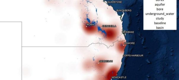
With that in mind, I hope to do two things with this post. Firstly, I want to share some of my outputs from the last few months; and secondly, I want to take stock of these and other outputs in preparation for the phase that lies ahead. I won’t try to cram everything into this post. Rather, I’ll focus on just a few recent developments here and aim to talk about the rest in a follow-up post. Specifically, this post covers three things: the augmentation of my dataset, the introduction of heatmaps to my geovisualisations, and the association of locations with thematic content. Continue reading Where are we now?