Category Archives: Feature

Adventures in harmonic space

Long, long ago, I studied music. In fact, when I finished high school, music was all I wanted to study. To be sure, I didn’t just want to study it: I wanted to compose it as well. 1 But I soon discovered that music theory was something worthy of study in itself, quite apart from the grounding it provided for composition. Music theory, especially the analysis of harmonies and harmonic progressions, provided a way to pop the hood on a piece of music (or even a whole genre) and learn what makes it tick. As if that weren’t exciting enough, I sensed that there were more profound truths waiting to be teased out of these harmonic structures. For if they offered clues about what makes music tick, then surely they said something about what makes us tick as well.

I never did pursue my vision of a grand unified theory of tonal harmony and psychoacoustics. I soon found that there were also other things worth studying, many of which came with the bonus incentive of career prospects. One thing led to another, and for better or worse, I ended up working for the government. And not as a music theorist. But to this day, I can’t help hearing a piece of music and thinking about what makes it tick. The theorist within me is always plugging away, even while the rest of me is just enjoying the tune.

Unsurprisingly then, when I started playing with network graphs about 18 months ago, among the first things I asked myself is what application they might have for music theory. The beauty of network graphs is that they can be used to represent just about anything. Any system or community of inter-related parts can be turned into a network of nodes and connections. So far on this blog I’ve used network graphs to explore the linkages among websites related to coal seam gas, and to identify clusters of documents containing duplicated text. On my other blog, I used network graphs to see how the names of different people and places featured across a collection of my posts.

In this post, I will use network graphs to visualise the relationships among chords within a piece of music. You could examine melodies in much the same way, by breaking them down to their individual notes and tracking which notes pair up and cluster together most often. But I suspect that there is more to be gained from visualising the harmonic relationships. Continue reading Adventures in harmonic space

Notes:

  1. Eventually, years later, I did get around to writing some music. And I have finally published some of the results onto Youtube.

Queensland’s Groundwater Database – The Movie!

(Just want to see the movies? Click here.)

Every bore is sacred

In Queensland, as in much of Australia, water is a scarce resource. Except in the monsoonal north, the annual rainfall tends to range from low to unreliable. Good years follow bad years; droughts follow floods. The continued availability of water for human use and environmental health cannot be taken for granted: it must be planned for. In Australia, the responsibility for this planning rests with the state and territory governments.

When I joined Queensland’s Department of Natural Resources 1 in 2006, the state’s surface water resources (rivers and overland flows) were pretty well accounted for. Water resource plans — the state’s legislative instrument for allocating water among competing uses — had been prepared for nearly every river basin in the state. The department was now grappling with the more difficult task of accounting for the state’s groundwater.

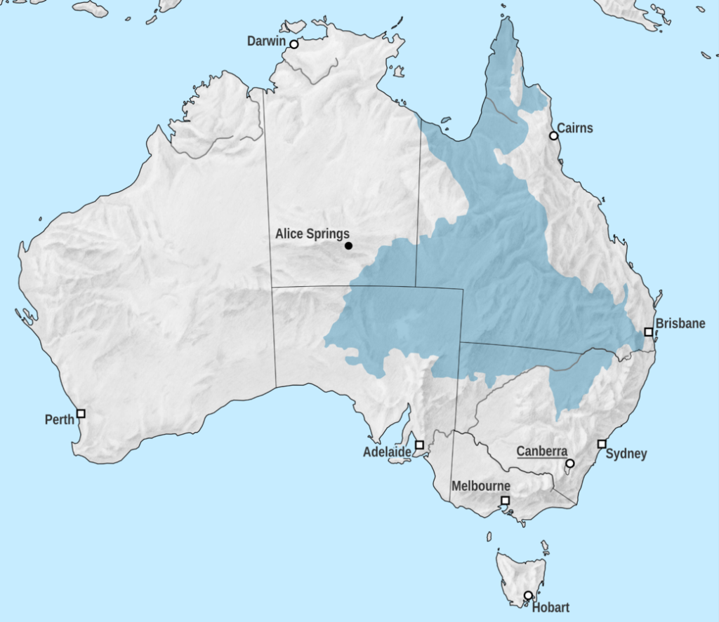
In many parts of Queensland, underground reservoirs (or aquifers) are the only reliable source of water. Across much of the state’s arid interior, human settlement and agricultural activities would be virtually impossible without water from the Great Artesian Basin — an enormous sequence of aquifers that underlies much of the eastern half of the country. Closer to the surface, there are numerous alluvial aquifer systems — the most significant being the alluvium of the Condamine River in the Darling Downs — which support regional towns and intensive irrigation districts.

The Great Artesian Basin.
The extent of the Great Artesian Basin (Image source: Wikipedia, contributed by Tentotwo.

Over the past century, many groundwater systems in Queensland have effectively been ‘mined’ as water has been taken at a rate faster than it is naturally replenished. Drastic reductions in water use from these systems have been (and are still being) enacted to return water extraction to within sustainable limits.

However, determining what these limits are is no trivial task. The workings of groundwater systems are largely hidden from view, and the only way to develop a picture of them is to drill holes in the ground and piece together the observations taken at each one. I remember a groundwater engineer in the department likening this process to punching holes into a book and reconstructing the plot by studying the confetti. That analogy might be a slight exaggeration, but it does illustrate why every hole drilled, and every bit of data collected, is so precious. We can really only guess at how a groundwater system works, and sometimes the data from a single hole will make all the difference between a good guess and a bad one. Continue reading Queensland’s Groundwater Database – The Movie!

Notes:

  1. The department wasn’t actually called this in all the time it was there, but for the sake of simplicity, that is what I am calling it here!